The Lands Commission has reaffirmed its commitment to deepening collaboration with Africa’s geospatial community and global partners to strengthen data-driven planning and accelerate sustainable development in Ghana.
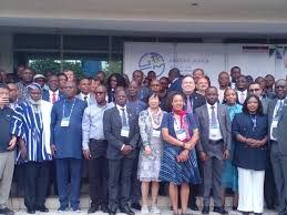
Professor Anthony Owusu-Ansah, the Executive Secretary of the Lands Commission, made the call during the opening of the Africa Geographic Information Systems (AfricaGIS) 2025 Session and the United Nations Global Geospatial Information Management (UN-GGIM) XI Joint Conference in Accra on Monday.
Prof. Owusu-Ansah, who represented the Minister of Lands and Natural Resources, Emmanuel Armah-Kofi Buah, emphasised the urgent need for Africa to build a resilient geospatial ecosystem capable of bridging development gaps and fast-tracking progress toward the United Nations Sustainable Development Goals (SDGs) by 2030.
“In today’s data-driven world, the value of geospatial information extends far beyond mapping. It is about connecting people, place, and policy, and integrating land, environment, infrastructure, and socio-economic data to inform decision-making,” Prof. Owusu-Ansah noted.
Prof. Owusu-Ansah highlighted Ghana’s ongoing efforts to modernise land administration through initiatives such as: Development of an enterprise land information system, preparation of a national geospatial policy, and establishment of a national spatial data infrastructure, as well as modernization of cadastral and registration systems
These projects, he explained, were aligned with the United Nations Integrated Geospatial Information Framework (UN-IGIF) principles and demonstrate Ghana’s commitment to building a comprehensive geospatial ecosystem that supports governance, investment, and inclusive development.
The five-day workshop, themed: “Harnessing Geospatial Intelligence for Africa’s Sustainable and Resilient Future” with the sub-theme, “Geospatial Foundation for Africa’s Development, Innovation and Resilience,” brought together policymakers, government agencies, academia, private sector innovators, and development partners.
Participants would engage in high-level plenary sessions and policy dialogues, UN-IGIF implementation workshops, AfricaGIS technical sessions, exhibitions and innovation showcases.
There would be leadership development programmes with strong youth and private sector involvement.
Organisers stressed that the joint conference represents a historic opportunity for African nations to strengthen geospatial infrastructure, close data gaps, and tackle pressing challenges such as climate change, urbanization, food security, disaster response, and digital inclusion.
Prof. Owusu-Ansah therefore called for collaboration, peer learning, and sustainable financing to ensure Africa’s geospatial transformation delivers lasting impact.